


Our crews regularly inspect poles, wires and other electricity assets as part of our work to keep power safe and reliable for our customers. These inspections allow us to identify potential issues and take action to reduce the risk of unplanned power outages.
We have a legal obligation to conduct inspections to mitigate risks to property owners and the wider community. Delaying inspections could increase safety risks.
How we inspect poles
Pole inspections begin with a visual check that includes photographing various components to spot any signs of wear, damage or decay. We then test the pole’s stability, looking for structural issues such as wood rot or corrosion. We also examine surrounding areas for soil erosion, overgrown vegetation and other issues that could affect the pole’s integrity. Finally, we record the condition and key details of each pole for future reference.
We inspect poles on a regular cycle; typically, every five years in low bushfire risk areas and every three years high risk areas. We may undertake annual inspections of poles nearing the end of their lifespan.
Accessing private property
At times, our inspectors may need to enter private properties to carry out a full assessment. In this scenario, we make every effort to minimise disruption and (where possible) notify property owners beforehand. If you are not home and it is safe to proceed, we may conduct the inspection and leave a note to let you know we have visited your property.
Inspections typically take 10 to 30 minutes (depending on access, the condition of the asset and the type of inspection being completed).
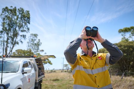
Drone inspections
Sometimes our crews use drones to inspect power poles, lines and other assets. This allows us to undertake a visual assessment before we can access our assets to complete a full inspection.
All drone operations are conducted by Certified Drone Operators approved by the Civil Aviation Safety Authority (CASA). Our team complies with all regulations under the Civil Aviation Act 1988 and adhere to the Civil Aviation Safety Regulations 1998.
Drone operators are strictly instructed to photograph only company assets, and where necessary, permission is sought before accessing private property.
Outcomes of inspections
Following inspections, our team provides site photos and detailed reports to maintenance crews to inform the planning and execution of any necessary work. If defects are identified, crews may need to return to repair or replace the pole or other assets. Clearing or trimming may be required if vegetation is overgrown, particularly in bushfire-prone areas. Poles with minor issues will be flagged for closer monitoring in future inspections.
Your role and responsibilities
Landowners have a role to play allowing quick and safe access to electricity assets on their property. These steps include:
- Keep easement areas clear – Don’t plant trees, build structures or store materials over or near powerlines and underground cables.
- Maintain clear access – Ensure gates and routes to equipment remain accessible.
- Inform us of requirements – Advise of locked gates, security alarms or pets.
- Secure animals – Prevent animals from causing harm.
About our power poles
Our poles are made from wood, concrete or steel and are designed for their location based on Australian standards.
The timber used for poles features natural textures that include splits in the wood and holes from knots. This means that some poles may look old or weathered. It is important to note that a pole’s aesthetic qualities do not necessarily impact on its strength.
Above and below ground inspection methods determine the condition of wooden poles, including the amount of sound wood, presence of rot or termites, the size and number of splits in the timber, height and diameter measurements.
Data from inspections is used to calculate each pole’s residual strength and safety factor. Based on this, the serviceability of the pole is assigned one of three classifications.
A new wood pole’s residual strength is well above its rated strength (2.5 times) and will typically reduce with age. We do not allow poles to deteriorate below their rated strength as they would not be considered strong enough to support infrastructure or withstand environmental factors such as high winds.
In 2021, we introduced a new digital management system to bring together in one place a full history of every pole in our network. The location, wood species, age, pole-top assets and inspection history as well as the results of aerial inspections by our helicopters are now captured in this system for every pole. This gives us even better information to work from in planning our annual asset management program.

Looking for something else in
Network safety
Explore another page


